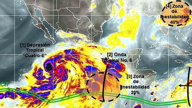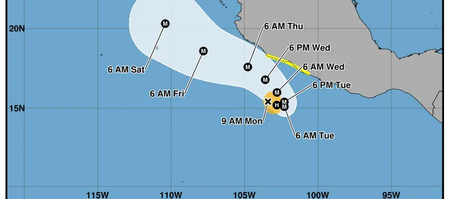








If you're still undecided about whether to watch the game of the Tri against Holland in a public place, or relocate your comfortable sofa in the room, takes into account that tropical depression 4-E - Douglas - could become the next hours in tropical storm will generate strong rains to very strong in Western, Central, southern and southeastern Mexico, warned Sunday the national meteorological service (SMN).
From 04:00 this Sunday, this tropical depression in the Pacific Ocean was located about 630 miles southwest of Manzanillo, Colima; to 850 to the South of Cabo San Lucas, Baja California Sur, and 445 to the South-southeast of Socorro Island, Colima.
The system has maximum winds sustained 55 kilometers per hour and gusts of up to 75 kilometers per hour, with movement towards the west-northwest at 26 kilometers per hour.
What does it mean?
Dense cloud with rain, wind and waves in Guerrero, Michoacan, Colima, Jalisco and Nayarit. The rains (from 75 to 150 mm) recorded in Michoacan and Guerrero, which includes the archipelagos of Rivillagigedo; In addition to precipitation very strong 50 to 75 mm in Jalisco and Colima, according to the weather forecast.
Sinaloa, Nayarit and Marias Islands will have rains and winds with gusts of 50 miles per hour and high waves of up to three meters high in Guerrero, Michoacan, Colima and Jalisco, added dependence in his morning statement.
The tropical depression is not the unique climatological phenomenon in Mexico.
A low pressure was located off the coast of Chiapas, where also recorded the tropical wave six. The interaction of these phenomena will facilitate the entry of moist air toward the States of the West, Central, South and Southeast of the country, where it will cause strong to very strong rainfalls.
A low pressure channel will continue on the interior of Mexico and, in combination with the entrance of humidity coming of the Pacific Ocean and the Gulf of Mexico, will give rise to rainfall with thunderstorms in the North, Center and East of the country.
The previous picture look very wet, but not so for the peninsula of Baja California, Sonora and Chihuahua will continue where the hot environment with maximum temperatures between 40 and 45 degrees Celsius, as a result of an anticyclonic circulation in the Northwest of the country.
[readon1 url="http://mexico.cnn.com/nacional/2014/06/29/la-tormenta-douglas-parece-asomarse-por-el-pacifico"]Source:mexico.cnn.com[/readon1]
The storm 'Douglas' seems to lean over the Pacific
- Details
- Vallarta Today Staff Editor
Typography
- Smaller Small Medium Big Bigger
- Default Helvetica Segoe Georgia Times
- Reading Mode