







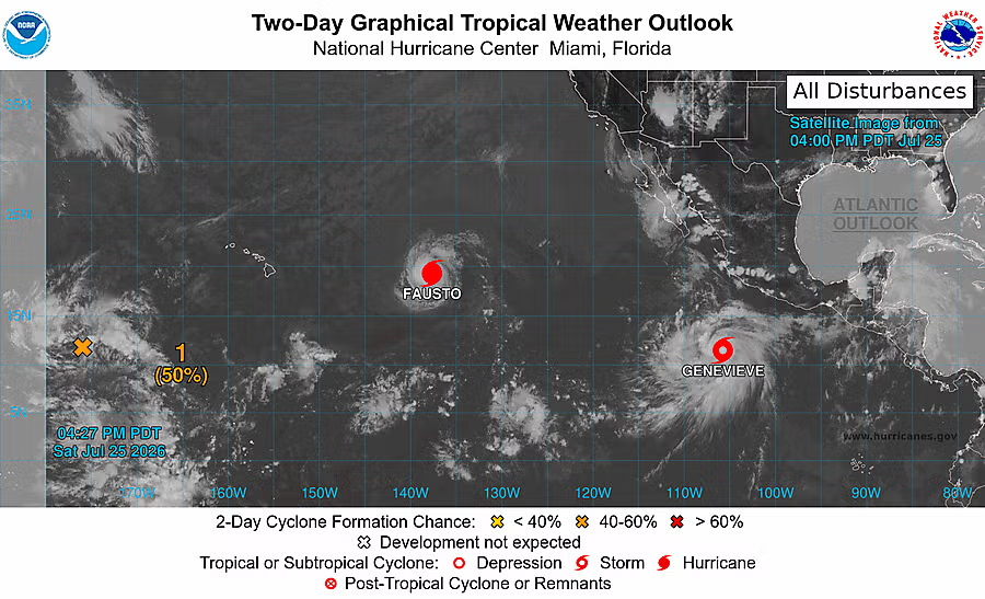
National Hurricane Center, Two-Day Graphical Tropical Weather Outlook
The National Hurricane Center is monitoring a developing cyclone as it moves west-northwest along the Pacific coastline. Although the storm's core is projected to remain at sea, its outer feeder bands are expected to push heavy rain showers, elevated ocean swells, and dangerous rip currents into coastal Jalisco and Nayarit through the weekend.
According to the latest graphical tropical weather outlook from the NHC, Genevieve sits off the coast of southern Mexico alongside Hurricane Fausto, which continues to move further westward out into open waters. Genevieve is expected to track slowly west-northwest over the coming days. While the core of the system stays offshore, atmospheric conditions across the region remain favorable for localized downpours, river swelling, and heightened surf along Pacific-facing beaches.
Civil Protection authorities in Jalisco and Nayarit recommend that mariners, tour operators, and beachgoers stay closely tuned to harbor master updates. Increased swells and severe rip currents are anticipated along southern beaches from Cabo Corrientes up through Punta de Mita, with short, heavy afternoon squalls likely as outer moisture bands interact with the Sierra Madre mountains. Boaters should secure mooring lines and check bilge pumps ahead of shifting coastal conditions.
Vallarta Today will continue to monitor official advisories and bring updates as new bulletins are issued by the National Hurricane Center.